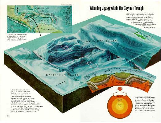
 This map shows an area of the Caribbean where there is a boundary between two tectonic plates. The American Plate is to the North, and the Caribbean Plate is to the South. Where they meet is the Cayman Trough, a deep valley where the plates pull apart. Where the plates separate, molten rock wells up and hardens on the edges of the plates. By studying the rocks in this deep trough, four times deeper than the Grand Canyon, scientists can learn about the Earth's mantle. This map shows an area of the Caribbean where there is a boundary between two tectonic plates. The American Plate is to the North, and the Caribbean Plate is to the South. Where they meet is the Cayman Trough, a deep valley where the plates pull apart. Where the plates separate, molten rock wells up and hardens on the edges of the plates. By studying the rocks in this deep trough, four times deeper than the Grand Canyon, scientists can learn about the Earth's mantle.
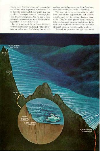
The cross section of the sea floor, below shows the different layers found at different depths. Unlike canyons on land, where the deepest rocks are the oldest, in the Cayman rift valley the deepest rocks are the youngest, formed by the magma crystallizing in the rift.
Fifth Graders visited Sandy Hook and are learning about the ocean in Science class.
What would YOU like to learn about the ocean?
Some 5th Graders have created webpages to help answer your questions.
Let's follow our journey on a map. Click here for interactive map.
THE OCEANS
About 70% of the Earth's surface is covered with oceans and seas, which contain about 97% of the planet's total water. This great amount of water affects our temperature and our climate. We can see this very clearly right now, during hurricane season, when powerful storms form over the ocean. The oceans soak up heat from the sun, and currents in the water move the heat around the Earth, warming the air and the neighboring land. The ocean is always moving because of currents.
Ocean Currents
Water moves deep in the ocean because of differences in water temperature and in salinity--that means how salty the water is. Water moves on the surface of the ocean because of the wind. The currents form into huge circular patterns called current gyres. Many currents have been named, but the seven major ones are: the West Wind Drift (or the Antarctic Circumpolar Current), East Wind Drift, the North and South Equatorial currents, the Peru Current, the Kuroshio Current, and the Gulf Stream. The Gulf Stream moves warm water from near the Gulf of Mexico across the Atlantic Ocean and along the West coast of Europe, warming the land. For this reason, even though Western Europe is at the same latitudes as Canada, it has a temperate climate similar to our own.
Click here to see an illustration of ocean currents.
Because the planet is rotating, the currents spin in different directions above and below the equator. In the Northern Hemisphere, the current gyres flow in a clockwise direction, and in the Southern Hemisphere, the gyres spin in a counterclockwise direction. this is called the Coriolis Effect.
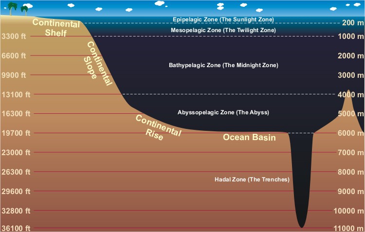
Layers of the Ocean
As this illustration shows, scientists think of the ocean as having layers. These are not sharply defined layers with clear boundaries, but rather different depths that are home to different types of marine life. As we go deeper, the light decreases and the pressure increases. Some very strange creatures live at the depths of the ocean--there's a poster about them in the 5th grade hall.
|
|
