| A | B |
|---|
| Geographic Regions | Coastal Plain, Appalachian Highland, Canadian Shield, Interior Lowlands, Great Plains, Rocky Mountains, Basin and Range, Coastal Range |
| Number of Geographic Regions | 8 |
| Location of the Coastal Plain region | located along the Atlantic Ocean and the Gulf of Mexico |
| Physical characteristics of the Coastal Plain region | Broad lowland providing many excellent harbors |
| Location of the Appalachian Highlands region | located west of Coastal Plain extending from eastern Canada to western Alabama; includes the Piedmont |
| Physical characteristics of the Appalachian Highlands region | Old, eroded mountains (oldest mountain range in North America) |
| Location of the Canadian Shield region | Wrapped around the Hudson Bay in a horseshoe shape |
| Physical characteristics of the Canadian Shield region | Hills worn by erosion and hundreds of lakes carved by glaciers; Holds some of the oldest rock formations in North America |
| Location of the Interior Lowlands region | located west of the Appalachian Mountains and east of the Great Plains |
| Physical characteristics of the Interior Lowlands region | Rolling flatlands with many rivers, broad river valleys, and grassy hills |
| Location of the Great Plains region | located west of Interior Lowlands and east of the Rocky Mountains |
| Physical characteristics of the Great Plains region | Flat land that gradually increases in elevation westward; grasslands |
| Location of the Rocky Mountains region | located west of the Great Plains and east of the Basin and Range stretching from Alaska almost to Mexico |
| Physical characteristics of the Rocky Mountains region | Rugged mountains and high elevations |
| Location of the Basin and Range region | located west of Rocky Mountains and east of the Sierra Nevadas and the Cascades |
| Physical characteristics of the Basin and Range region | areas of varying elevations containing isolated mountain ranges and Death Valley |
| Location of the Coastal Range region | located along the Pacific Coast and stretches from California to Canada |
| Physical characteristics of the Coastal Range region | rugged mountains and fertile valleys |
| the Continental Divide | located in the Rocky Mountains; determines the directional flow of the rivers |
| Death Valley | located in the Basin and Range region; the lowest point in North America |
| continents | large land masses surrounded by water |
| the 7 continents | North America, South America, Africa, Asia, Australia, Antarctica, Europe |
| the 5 oceans | Atlantic, Pacific, Arctic, Indian, Southern |
| Eurasia | the land mass that contains Europe and Asia |
| the purpose of bodies of water | support interaction among regions, form borders, and create links to other areas |
| major oceans and gulfs in the United States | Atlantic, Pacific, Gulf of Mexico |
| major rivers in the United States | Mississippi, Missouri, Ohio, Columbia, Colorado, Rio Grande, St. Lawrence |
| major lakes in the United States | the Great Lakes (Superior, Michigan, Huron, Erie, Ontario) |
| provides access to other areas of the world | the location of the United States with its Atlantic and Pacific coasts |
| early uses of the Atlantic Ocean | served as a highway for explorers, early settlers, and later immigrants |
| the Ohio River | the gateway to the West |
| grew in the midwest along the Great Lakes | Inland port cities |
| Mississippi and Missouri Rivers | transportation arteries for farm and industrial products; links to ports and other parts of the world |
| Columbia River | explored by Lewis and Clark |
| Colorado River | explored by the Spanish |
| Rio Grande River | forms the border with Mexico |
| Pacific Ocean | an early exploration route/destination |
| Gulf of Mexico | provided the French and Spanish with exploration routes to Mexico and other parts of America |
| St. Lawrence River | forms part of the northeastern border with Canada and connects the Great Lakes to the Atlantic Oceans |
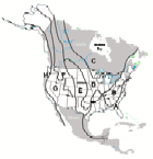 | A-Coastal Plain B-Appalachian Highlands C-Canadian Shield D-Interior Lowlands E-Great Plains F-Rocky Mountains G-Basin and Range H-Coastal Range |
