 |
Java Games: Flashcards, matching, concentration, and word search. |
 |
|
Early Maps
Moving into the Modern World
|
| A | B |
|---|
Ptolemy's Geography,  | In his book Geograpy (150 AD), Ptolemy used math and geometry to develop a manual for how to map the earth using a rectangle and intersecting lines. The map was used until the early 17th century. Ptolemy described the latitude and longitude of more than 8,000 locations in Europe, Asia, and Africa (however, Africa blends into Asia, and so is not depicted as circumnavigable). His world was missing the Americas, Australia, southern Africa, the Far East, the Pacific Ocean, and most of the Atlantic Ocean. However, Ptolemy's maual was considered a foundation in cartography. |
Al-Idrisi's World Map, 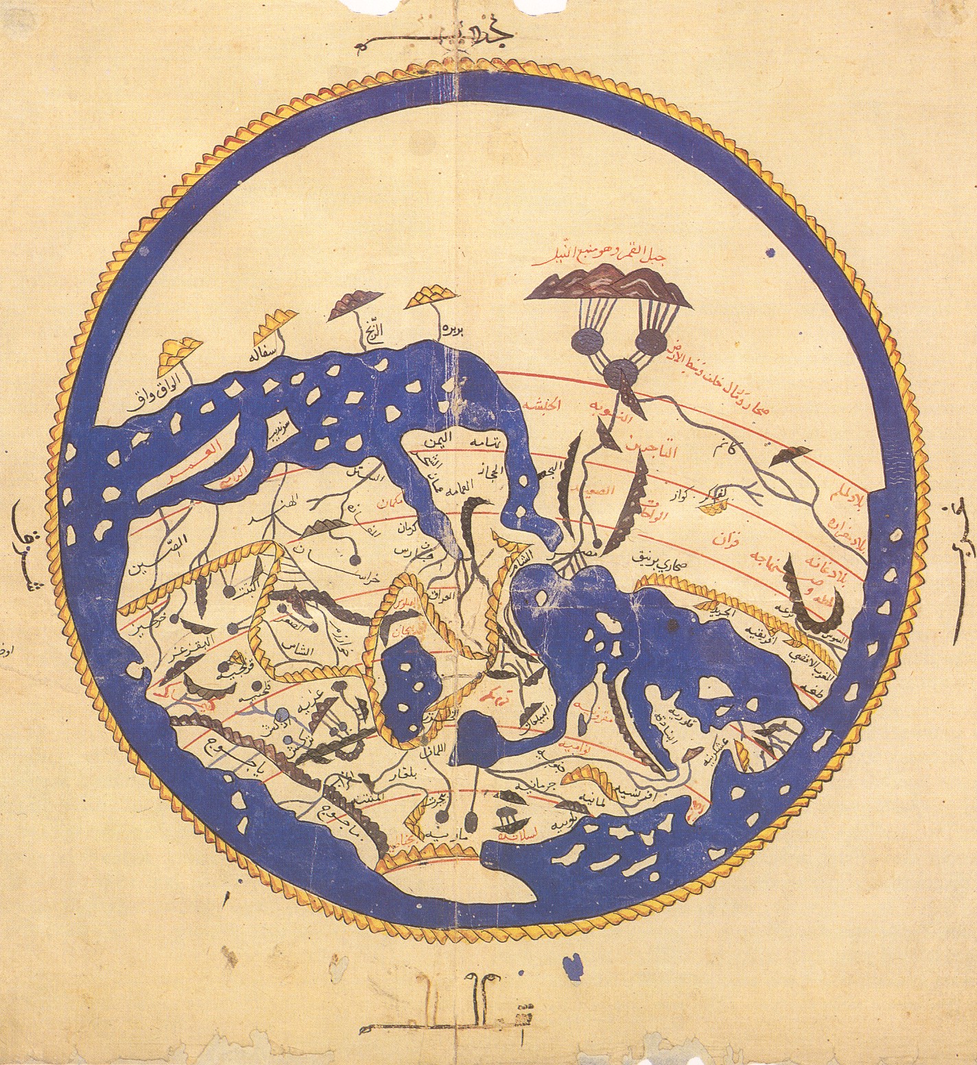 | Al-Idrisi traveled to Sicily to create his World Map for King Roger II in 1154. Al-Idrisi's map was in the Arabic language, drawing on Jewish, Greek, Christian, and Islamic traditions. The guide contained two world maps: a small circular map and 70 regional maps that could be stitched together. Unlike Christian maps, al-Idrisi's map put south at the top, in the Muslim tradition. Africa is depicted as circumnavigable. |
Hereford's Mappa Mundi,  | In 1300, Hereford created the Mappa Mundi. The map depicts the world according to medieval Christians. The map does not depict space, but time--biblical time; Christ looms over the top of the map. The map travels from the Garden of Eden at the top down to the Pillars of Hercules. Jerusalem is depicted in the center, marked with a cross. Africa is depiced off to the right, with monsters, because the unknown was considered a dangerous place. |
Kwon Kun's Kangnido,  | In 1402, the Korean map Kangnido was created by Kwon Kun. It is interesting to note that north is depicted at the top, though it is not a Western map. A possible theory for this is that the people look up northwards in repsect to the emperor, and the emperor looks south to his subjects. Europe is depicted as a tiny speck in the upper left, and India is barely visible. Africa is depicted as circumnavigable. China is in the middle, with Korea (disproportionately large) to its right and Japan in the bottom right. |
Waldseemuller's Universalis Cosmographia,  | German cartographer Martin Waldseemuller created the Universalis Cosmographia in 1507. This is the first map to recognize the Pacific Ocean and the separate contintent America. The map consists of 12 woodcuts and incorporates the latest discoveris by European explorers. Waldseemuller's map is considered "America's birth certificate"--the Library of Congress bought it from a German prince for $10 million! |
Ribeiro's World Map,  | Portuguese cartographer Diogo Ribeiro created his World Map in 1529. The map was created during a dispute between Spain and Portugal over the Moluccas (an island chain in present-day Indonesia), a hub for the spice trade. In 1494, Spain and Portugal had signed a treaty which divided the world's newly discovered lands in two. After Ferdinand Magellan circumnavigated the globe in 1522, Ribeiro (who worked for the Spanish crown), placed the "Spice Islands" inaccurately--just inside the Spanish half of the world map--though they belonged to Portugal. |
Mecator's World Map,  | In 1569, cartographer Gerardus Mercator attempted to mimic the curvature of the earth's surface on a flat piece of paper. Mercator created the map for European navigators. Mercator was accused of Eurocentrism, because his projection increasingly distorts territory as you go further north and south from the equator. |
Blaeu's Atlas Maior, .jpg) | Joan Blaeu created his Atlas Maior in 1662 while working for the Dutch East India Company. The atlas includes hundreds of baroque maps. Unlike other mapmakers, Blaeu did not place the earth at the center of the univers. Instead, at the top of the map he depicts the sun as the center of the five known planets at the time, following Copernicus's theory of the cosmos. Blaeu also has drawings of Ptolemy and Copernicus in the upper left and right, respectively. |
Cassini's Map of France,  | Starting under the reign of Louis XIV, four generations of the Cassini family made the first attemp to survey and map every meter of France. The Cassinis used the science of triangulation to create this 200-sheet topographic map. The map was nationalized in the late 18th century. The map was completed in 1744. |
|
|
|
|
|
|
| |
