| A | B |
|---|
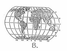
| The Projection used primarily for ship navigation | Mercator |
| Projection used primarily for airlplane navigation | Polar |
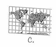
| Projection used primarily for data representation | Robinson |
| Channel Tunnel | Chunnel |
| Home of the Parthenon | Athens |
| North, South, East, West | Cardinal Directions |
| Natural boundary between the U.S. and Mexico | Rio Grande |
| Person with Native American and European ancestors | mestizo |
| roads, bridges and power plants | infrastructure |
| International headquarters of NATO | Belgium |
| A rise in prices caused by a decrease in the value of a nation's currency | inflation |
| An area of plains at or near the foot of a mountqin region | Piedmont |
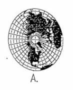 | Polar Projection |
 | Robinson Projection |
 | Mercator Projection |
